Due to continual advances in technology, many organisations have been left with the dilemma of which solutions to use, to capture the data they need.
How we can help
Our data capture team works closely with clients to understand their specific requirements, enabling them to derive full benefit of the data over its lifecycle use. Our data capture solutions support multiple use cases, from informed concept and design stage activities to supporting intelligent decision making for owner-operators.
Our team offer a wide range of surveying methods which allows us to ensure we are always using the right technology for the job. Our experience across multiple industries and design disciplines gives us the knowledge to make sure we meet our client’s requirements, delivering the data they need in the best format to suit their project requirements.
Our team, work collaboratively with clients to understand their needs and utilise the most suitable technology solution to fulfil their requirements. By doing so, our clients see benefits such as:
- Cost savings due to faster methods of capture and minimum disruption
- Fully co-ordinated outputs for easy project integration
- Geolocation to suit ordnance or site datum’s
- Improved health and safety, minimising the need for specialist access equipment
- Much more information captured than if traditional methods were used
- The ability to use the data in a 3D environment
- Variety of outputs ranging from 2D drawings to 3D point clouds
Our top three digital data capture methods, explained:
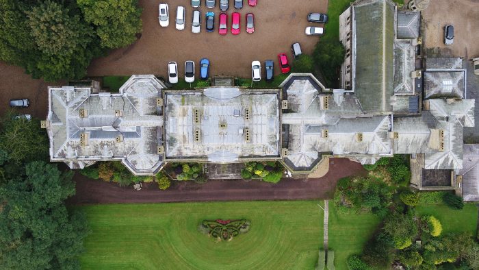
1. UAV & Mobile mapping
UAV (Unmanned Aerial Vehicle) and mobile mapping solutions offer an alternative to traditional survey and reporting methodology, visually improving the understanding across projects and businesses. Incorporating the latest 360-degree cameras, sensors and drones, our team can provide a range of visualisations from single high-resolution images, to fully immersive virtual tours with embedded annotation and reporting.
Our approach
To achieve the desired results for our clients, we utilise:
- 360-degree Google street view outputs
- 360-degree photography
- Annotated Virtual tours
- High resolution photography
- High resolution videography
Specific benefits
- Communication of traditional reports in an easy to use and visual format
- Easy access from mobile devices
- Free view software solution, enabling trouble free access to your data
- Immersive deliverables, enabling a context-based review
- Integrated images, video and documentation, enhancing user understanding
- The ability to showcase your business or project
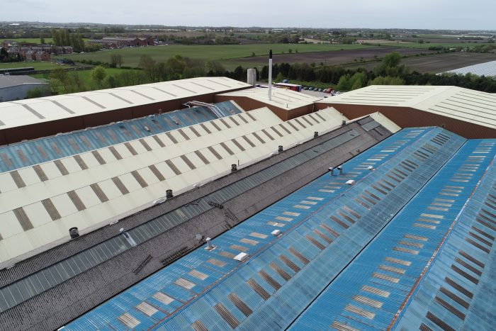
2. Inspections
As well as digitally capturing and recording environments, our team are able to provide inspection services to supplement our survey data providing a comprehensive overview of buildings and assets.
Whilst camera technology can be used to create a variety of different data sets such as, 3D point clouds and Digital Terrain Models (DTM), the use of thermal imaging and infra-red cameras can provide further insights on construction sites. With the right combination and specification, captured data can be used throughout the project and asset lifecycle, from cut/fill analysis at the start of a project, to as-built validation at handover, and inspection during a structure’s operation.
Approach
To achieve the desired results for our clients, we utilise:
- Aerial surveys and inspection
- Condition surveys
- Construction surveillance
- Utilities mapping
Specific benefits
- Avoidance of costly and time-consuming disputes
- Confined spaces and hazardous environments can now be captured
- Improved health and safety, minimising the need for specialist access equipment and working at height
- Measurable output
- Minimum disruption to live sites
- Spatial and volume measurements
- Surface and volume analysis
3. Scan to BIM
Accurate, intelligent Building Information Modelling (BIM) models can be created from 3D laser scan data by capturing large sites and buildings in high levels of detail.
Using 3D authoring software, we are able to accurately re-create an as-built model of an existing facility or asset, and then using the intelligent 3D model manipulate, change, analyse and adapt all aspects of the as-built model to suit the specific projects requirements.
Creating 3D geometric models which accurately reflect the asset allows meta-data to be attributed, creating intelligence which can be harnessed to better understand and operate it.
Our approach
To achieve the desired results for our clients, we utilise:
- Construction verification toolsets
- Scan to BIM solutions
Specific benefits
- Construction verification reporting
- Enables virtual review and coordination activities
- Models can be visualised and rendered for stakeholder engagement and promotional purposes
- Retrospective production of a BIM
- Supports remote and field BIM access
To find out more about Digital Capture capabilities, please get in touch with Andy Hassall by calling 0161 7071516 or send him an email here.